Grand Rapids area 2013 flood
-
SD80MAC

- Ingersoll's Mr. Michigan
- Posts: 10645
- Joined: Thu Mar 10, 2005 4:59 pm
- Location: Grand Rapids
Re: Grand Rapids area 2013 flood
Please understand I meant no actual disrespect with my comment. I knew Don had likely not seen the info he was looking for earlier in the thread and was trying to be funny. My apologies.
"Remember, 4 mph is a couple, 5's a collision!"
http://flickriver.com/photos/conrail680 ... teresting/

http://flickriver.com/photos/conrail680 ... teresting/
-
AARR
- Incognito and Irrelevant
- Posts: 38747
- Joined: Wed Dec 22, 2004 7:39 pm
- Location: Washington, MI
Re: Grand Rapids area 2013 flood
Im such a putz sometimes...I kept looking for the picture you were referencing but didn't see it until now. Its the overhead pictureSD80MAC wrote:Please understand I meant no actual disrespect with my comment. I knew Don had likely not seen the info he was looking for earlier in the thread and was trying to be funny. My apologies.
PatC created a monster, 'cause nobody wants to see Don Simon no more they want AARR I'm chopped liver, well if you want AARR this is what I'll give ya, bad humor mixed with irrelevant info that'll make you roll your eyes quicker than a ~Z~ banhammer...
-
SD80MAC
- Ingersoll's Mr. Michigan
- Posts: 10645
- Joined: Thu Mar 10, 2005 4:59 pm
- Location: Grand Rapids
Re: Grand Rapids area 2013 flood
No, I was referencing the shots I posted on page 1.

Flooding by conrail6809, on Flickr

There's the water by conrail6809, on Flickr
Flooding by conrail6809, on Flickr

"Anchoring" The Bridge by conrail6809, on Flickr

Grand River Flood by conrail6809, on Flickr
Flooding by conrail6809, on Flickr
There's the water by conrail6809, on Flickr
Flooding by conrail6809, on Flickr
"Anchoring" The Bridge by conrail6809, on Flickr
Grand River Flood by conrail6809, on Flickr
"Remember, 4 mph is a couple, 5's a collision!"
http://flickriver.com/photos/conrail680 ... teresting/
http://flickriver.com/photos/conrail680 ... teresting/

Re: Grand Rapids area 2013 flood
Here's one more photo to add to the collection in this thread. I took it Sunday evening when the water was nearing its peak.

I also found this online and thought it was appropriate for this thread:
http://www.quickmeme.com/meme/3u1ea0/
I also found this online and thought it was appropriate for this thread:
http://www.quickmeme.com/meme/3u1ea0/
-
Saturnalia
- Authority on Cat
- Posts: 15438
- Joined: Wed Sep 28, 2011 7:54 pm
- Location: Michigan City, IN
- Contact:
Re: Grand Rapids area 2013 flood
I think most of us (at least from Grand Rapids) have seen the fish in the window picture, taken from a flooded window across from the GR Public Museum. Well, it's been making the rounds on the web. Apparently, someone photoshopped the mayor in with an interesting sign:
http://tribwxmi.files.wordpress.com/201 ... twell.jpeg
(West Michiganders should get the joke)
http://tribwxmi.files.wordpress.com/201 ... twell.jpeg
(West Michiganders should get the joke)

Re: Grand Rapids area 2013 flood
There is a facebook page dedicated to making funny comments on Heartwell's sign. I can't remember the page name right now though.MQT3001 wrote:I think most of us (at least from Grand Rapids) have seen the fish in the window picture, taken from a flooded window across from the GR Public Museum. Well, it's been making the rounds on the web. Apparently, someone photoshopped the mayor in with an interesting sign:
http://tribwxmi.files.wordpress.com/201 ... twell.jpeg
(West Michiganders should get the joke)
https://www.flickr.com/photos/jimthias/
GRHC - you know every night I can imagine he is in front of his computer screen sitting in his underwear swearing profusely and drinking Blatz beer combing the RailRoadFan website for grammatical errors.
GRHC - you know every night I can imagine he is in front of his computer screen sitting in his underwear swearing profusely and drinking Blatz beer combing the RailRoadFan website for grammatical errors.
-
Trainman223
- Railroadfan...fan
- Posts: 51
- Joined: Wed Apr 17, 2013 9:10 pm
Re: Grand Rapids area 2013 flood
Lake Judd is no more and the clean up takes place. A big front end loader is scooping the mountain of sand into tandem semi trailers.
YouTube: www.youtube.com/user/bozerabc123
-
Saturnalia
- Authority on Cat
- Posts: 15438
- Joined: Wed Sep 28, 2011 7:54 pm
- Location: Michigan City, IN
- Contact:
Re: Grand Rapids area 2013 flood
Can't imagine what biological hazards were there this week. I think I'll wait for it to dry out for a day or twoTrainman223 wrote:Lake Judd is no more and the clean up takes place. A big front end loader is scooping the mountain of sand into tandem semi trailers.
I have a Lake Michigan Water Level Update from Bill Steffen with WOOD TV 8 out of GR:
Here is a MODIS image of Lake Michigan. You can see the brown Grand River water being taken south in Lake Michigan due to the NW wind:Grand River Flood – helicopter view from WOOD-TV (more helicopter pics. here). Click on the picture to enlarge. The water level of Lake Michigan climbed 3″ in the past week. That’s after going up 3″ in the previous 6 days. So, the water level of Lake Michigan has jumped up 6″ in the last 13 days! That’s a remarkable increase! An inch of water added to Lake Michigan is 390 billion gallons. So, a 6-inch increase means we have added 2.34 TRILLION gallons of water to the lake (and 2.4 trillion gallons to Lake Huron)! With area rivers still at very high levels, we’ll likely add another 2″ to that in the next week. We’ll have very little precipitation in the next 5 days and evaporation rates should be back to average. The past two weeks have also been cloudier than average, with relatively high humidity, cutting down on evaporation. Ice cover hung on until today in Green Bay. So other factors have been favorable for increased lake levels. See the thread below on the satellite pictures where you can actually see the muddy water of the Grand River extending at least 5 miles out into the lake and moving down the shore past Holland with the prevailing NW wind today. Lake Michigan is up 8″ in the last month, but is still down 7″ year-to-year. It’s 21″ below the century average for April, but now 9″ above the lowest April level back in 1964. Question…if the lake levels go up significantly, will we be able to do less dredging?
http://coastwatch.glerl.noaa.gov/modis/ ... 3.250m.jpg
-
SD80MAC
- Ingersoll's Mr. Michigan
- Posts: 10645
- Joined: Thu Mar 10, 2005 4:59 pm
- Location: Grand Rapids
Re: Grand Rapids area 2013 flood
I was reading the other day that the water dumping into the lake from the Grand is incredibly contaminated. They tested it for e coli, and I can't recall the science stuff completely, but it showed the amount of e coli cells per one little tiny drop of water was over 500. Anything over 100 is supposed to be dangerous. I think I'd be waiting a long time to swim near Grand Haven...
"Remember, 4 mph is a couple, 5's a collision!"
http://flickriver.com/photos/conrail680 ... teresting/
http://flickriver.com/photos/conrail680 ... teresting/

Re: Grand Rapids area 2013 flood
Here's a satellite photo from Woodtv 8, showing the Grand River in early April, and the day the river crested in downtown Grand Rapids.

Jeff O.
Celebrating 11 years dial-up free!
(18:36:45) MagnumForce: Railfanning is way more fun when you stop caring about locomotives and signals
(19:11:29) cbehr91: I can't believe I'm +1ing Brent but +1
Celebrating 11 years dial-up free!
(18:36:45) MagnumForce: Railfanning is way more fun when you stop caring about locomotives and signals
(19:11:29) cbehr91: I can't believe I'm +1ing Brent but +1

Re: Grand Rapids area 2013 flood
Went back to the City Market Spur bridge this morning. Bridge looks ok visually, but the debris is stacked up. Lots of washed out embankment on the south side of the creek. Abutments look good on both sides of the bridge. I took a couple pics with my phone. Not great, but a good representation.


Just a Fat Guy
Re: Grand Rapids area 2013 flood
This is what the river looked like on Saturday, 4/27/13.

And the flotsam or jetsam or whatever at Judd St.

And the flotsam or jetsam or whatever at Judd St.
Jeff O.
Celebrating 11 years dial-up free!
(18:36:45) MagnumForce: Railfanning is way more fun when you stop caring about locomotives and signals
(19:11:29) cbehr91: I can't believe I'm +1ing Brent but +1
Celebrating 11 years dial-up free!
(18:36:45) MagnumForce: Railfanning is way more fun when you stop caring about locomotives and signals
(19:11:29) cbehr91: I can't believe I'm +1ing Brent but +1
-
Saturnalia
- Authority on Cat
- Posts: 15438
- Joined: Wed Sep 28, 2011 7:54 pm
- Location: Michigan City, IN
- Contact:
Re: Grand Rapids area 2013 flood
Finally got an opprotunity to upload my remaining pics, taken right during the height of the flood, plus two graphs from the USGS that show the river's climb, crest, and downfall that is still not complete!

Flood 13 by MQT3001, on Flickr

Flood 14 by MQT3001, on Flickr

Flood 15 by MQT3001, on Flickr

Flood 16 by MQT3001, on Flickr

Flood 17 by MQT3001, on Flickr

Flood 18 by MQT3001, on Flickr

Flood 19 by MQT3001, on Flickr

Flood 20 by MQT3001, on Flickr
Flood 21 by MQT3001, on Flickr
Flood 22 by MQT3001, on Flickr
You can see in the last pic before the graphs the CSX crew installing a new culvert in an effort to bridge the pond at the West End. They completed it about a half hour after I took the picture.
Flood 13 by MQT3001, on Flickr
Flood 14 by MQT3001, on Flickr
Flood 15 by MQT3001, on Flickr
Flood 16 by MQT3001, on Flickr
Flood 17 by MQT3001, on Flickr
Flood 18 by MQT3001, on Flickr
Flood 19 by MQT3001, on Flickr
Flood 20 by MQT3001, on Flickr
Flood 21 by MQT3001, on Flickr
Flood 22 by MQT3001, on Flickr
You can see in the last pic before the graphs the CSX crew installing a new culvert in an effort to bridge the pond at the West End. They completed it about a half hour after I took the picture.
Re: Grand Rapids area 2013 flood
I'm curious to know if there will be some investigating done as to why there was so much flooding SOUTH of 196 in Wyoming, specifically between Ivanrest and Sanford. Where the hell did all that water come from? If it's from the Grand, there was pretty much only one way for it to get there...and if so, they COULD have prevented it.
https://www.flickr.com/photos/jimthias/
GRHC - you know every night I can imagine he is in front of his computer screen sitting in his underwear swearing profusely and drinking Blatz beer combing the RailRoadFan website for grammatical errors.
GRHC - you know every night I can imagine he is in front of his computer screen sitting in his underwear swearing profusely and drinking Blatz beer combing the RailRoadFan website for grammatical errors.
-
Raildudes dad
- Roadmaster
- Posts: 4761
- Joined: Fri Dec 23, 2005 9:12 am
- Location: Grand Rapids, MI
Re: Grand Rapids area 2013 flood
The Grand was already pretty high when the big rain hit. Buck and Plaster Creek came up real quick and with the Grand high the water spread out higher than a "normal" flood would have been. The streams started to receded about the time the high water on the Grand arrived in GR and that crest keep the lower reaches of the creeks at abnormally high levels. This all happened in the area you are questioningJ T wrote:I'm curious to know if there will be some investigating done as to why there was so much flooding SOUTH of 196 in Wyoming, specifically between Ivanrest and Sanford. Where the hell did all that water come from? If it's from the Grand, there was pretty much only one way for it to get there...and if so, they COULD have prevented it.
Re: Grand Rapids area 2013 flood
Buck Creek and Plaster Creek flooded the area I mentioned? Hmmm...that doesn't seem possible. The water from Buck Creek never made it north of 28th St. and Plaster is nowhere near the area I'm referring to.Raildudes dad wrote:The Grand was already pretty high when the big rain hit. Buck and Plaster Creek came up real quick and with the Grand high the water spread out higher than a "normal" flood would have been. The streams started to receded about the time the high water on the Grand arrived in GR and that crest keep the lower reaches of the creeks at abnormally high levels. This all happened in the area you are questioningJ T wrote:I'm curious to know if there will be some investigating done as to why there was so much flooding SOUTH of 196 in Wyoming, specifically between Ivanrest and Sanford. Where the hell did all that water come from? If it's from the Grand, there was pretty much only one way for it to get there...and if so, they COULD have prevented it.
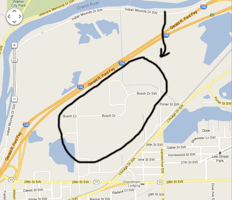
What I'm getting at is I believe MOST of the water in that area came from the Grand...through the Kent Trails underpass on 196. Would you disagree with that observation?
The black arrow represents the water flow from the Grand through the levee known as 196 via the Kent Trails underpass:
Last edited by J T on Wed May 01, 2013 10:41 pm, edited 2 times in total.
https://www.flickr.com/photos/jimthias/
GRHC - you know every night I can imagine he is in front of his computer screen sitting in his underwear swearing profusely and drinking Blatz beer combing the RailRoadFan website for grammatical errors.
GRHC - you know every night I can imagine he is in front of his computer screen sitting in his underwear swearing profusely and drinking Blatz beer combing the RailRoadFan website for grammatical errors.
-
Saturnalia
- Authority on Cat
- Posts: 15438
- Joined: Wed Sep 28, 2011 7:54 pm
- Location: Michigan City, IN
- Contact:
Re: Grand Rapids area 2013 flood
There is still water over Chicago Drive by Lamar Park...annoying when trying to chase, as one is forced to detour 
Re: Grand Rapids area 2013 flood
That is coming from the sewer system. At least it was when I was there watching (and videoing) cars plowing through it the first Saturday of the flood.MQT3001 wrote:There is still water over Chicago Drive by Lamar Park...annoying when trying to chase, as one is forced to detour
https://www.flickr.com/photos/jimthias/
GRHC - you know every night I can imagine he is in front of his computer screen sitting in his underwear swearing profusely and drinking Blatz beer combing the RailRoadFan website for grammatical errors.
GRHC - you know every night I can imagine he is in front of his computer screen sitting in his underwear swearing profusely and drinking Blatz beer combing the RailRoadFan website for grammatical errors.
Re: Grand Rapids area 2013 flood
That's the industrial park off Ivanrest...right? The artificial grade that the Kent trails uses always floods when the river comes up. Banks aren't very high in that area, plus it came up a long way. It's also relatively flat in that area. If it wasn't for the highway, the river would probably have been all over that area.
Just a Fat Guy
Re: Grand Rapids area 2013 flood
Right. And much of the flooding in that area COULD have been avoided. Instead, they decided to dump a buttload of sand on Market St near Godfrey. Can you figure out what I'm getting at?pudgy wrote:That's the industrial park off Ivanrest...right? The artificial grade that the Kent trails uses always floods when the river comes up. Banks aren't very high in that area, plus it came up a long way. It's also relatively flat in that area. If it wasn't for the highway, the river would probably have been all over that area.
Just sayin'...if I were a business that got flooded in that area and I knew there was a way to control it, I'd be a little pissed right now.
https://www.flickr.com/photos/jimthias/
GRHC - you know every night I can imagine he is in front of his computer screen sitting in his underwear swearing profusely and drinking Blatz beer combing the RailRoadFan website for grammatical errors.
GRHC - you know every night I can imagine he is in front of his computer screen sitting in his underwear swearing profusely and drinking Blatz beer combing the RailRoadFan website for grammatical errors.