Page 1 of 5

Grand Rapids area 2013 flood

Posted: Fri Apr 19, 2013 10:56 pm
by J T
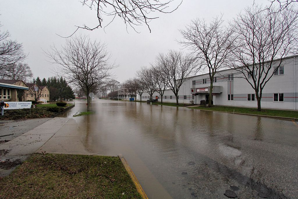
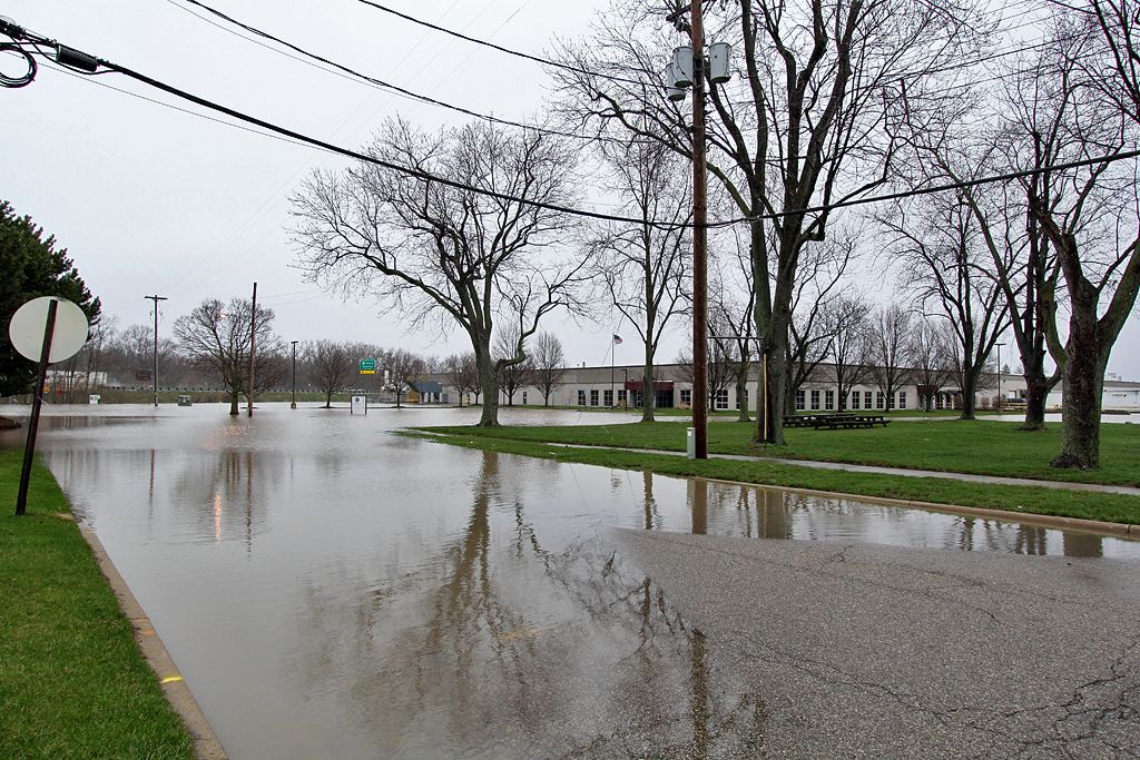
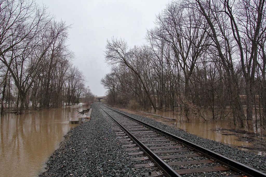
They are calling it a "once in a lifetime flood"...a "100-year flood." By Sunday night, they are predicting a foot over the original record.

I went out and took some pics these evening, and plan on getting many more as the water rises over the next couple of days. I will adding them slowly as I get around to processing them.

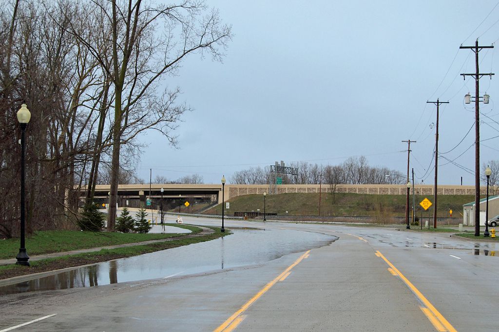
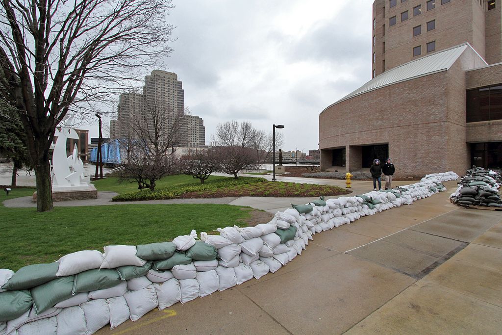
For starters, this is by the "blue bridge" downtown (which once upon a time carried rail traffic -- for the 1% who didn't know that. haha)...sandbags are ready!

Image


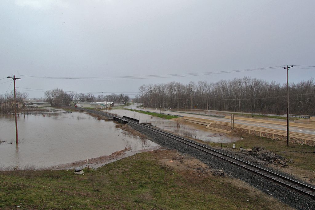
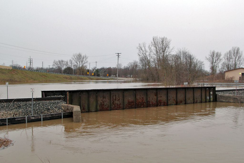
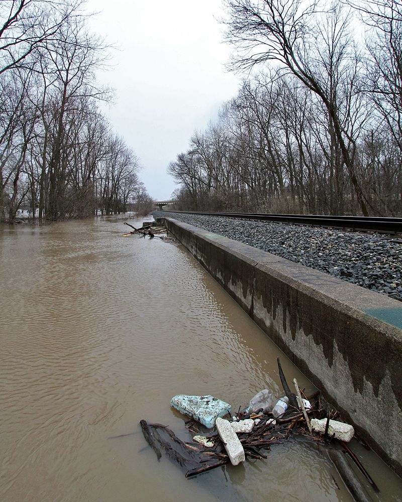
CSX over Buck Creek in Grandville.
Image


This is the bottom of the bridge...I'd estimate the water is about 8-10 feet higher than its normal level:
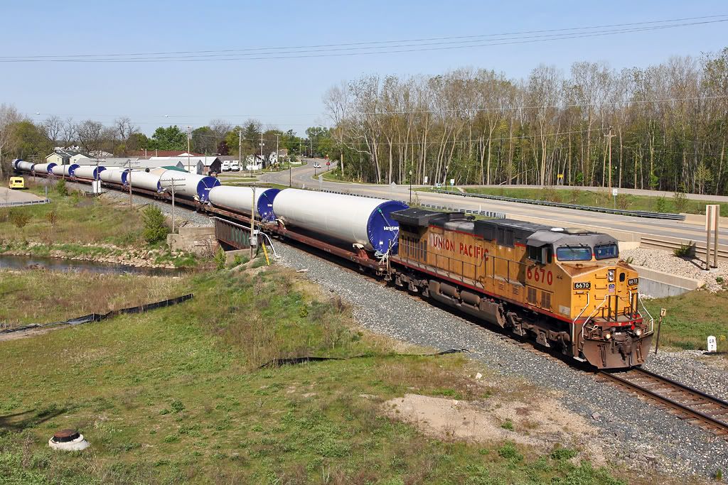
Image


For reference:
Image

Re: Grand Rapids area 2013 flood

Posted: Fri Apr 19, 2013 11:27 pm
by J T
Franklin Street in Grandville. This water is from Buck Creek...over a half mile away:
Image


Broadway Street, a few hundred yards east of Buck Creek:
Image

Re: Grand Rapids area 2013 flood

Posted: Sat Apr 20, 2013 6:02 am
by pudgy
Buck Creek flows into the grand river just north of 196. The highway separates the grand from Grandville. The volume of water in the grand is backing up into the creek and the flow of the creek is trying to push the water back. Its a perfect storm for the areas around the Chicago drive /196 interchange. Water is just going every way it can...its a mess. Chicago drive is now closed, as is all of the ramps off the highway.

Re: Grand Rapids area 2013 flood

Posted: Sat Apr 20, 2013 6:14 am
by AARR
That reference picture of the bridge really hits home how high the water has risen!

Re: Grand Rapids area 2013 flood

Posted: Sat Apr 20, 2013 7:59 am
by J T
pudgy wrote:Chicago drive is now closed, as is all of the ramps off the highway.
I managed to sneak by the barriers for the Baldwin ramps last night to get some photos. Only the westbound lanes just past the entrance to the Clean Water Plant have water in them and the eastbound lanes are free and clear. They could easily keep the east bound ramp open to 196 to ease the congestion that the detour to 44th Street is causing.

Re: Grand Rapids area 2013 flood

Posted: Sat Apr 20, 2013 8:19 am
by J T
See, no reason to close the east bound ramp to 196 for Friday rush hour traffic. I realize the water is probably going to get higher over the weekend warranting the closure, but it was premature for Friday afternoon, IMO:

Image

Rush creek:
Image


Image


Reference photo:
Image

Re: Grand Rapids area 2013 flood

Posted: Sat Apr 20, 2013 8:37 am
by AARR
Here's J T going to get his pictures of the flood from a unique POV Image

Re: Grand Rapids area 2013 flood

Posted: Sat Apr 20, 2013 8:40 am
by J T
If only it were warm enough for that, Don! :lol:

Re: Grand Rapids area 2013 flood

Posted: Sat Apr 20, 2013 10:12 am
by Jochs
I figured JT would either get a boat, or a wetsuit and waterproof camera and swim, and take photos of the flood from trees. :mrgreen:

Re: Grand Rapids area 2013 flood

Posted: Sat Apr 20, 2013 2:40 pm
by Michael
Great photos JT.

Here is a live webcam from the campus of Grand Valley State University
http://148.61.146.223/view/viewer_index.shtml

Re: Grand Rapids area 2013 flood

Posted: Sat Apr 20, 2013 3:14 pm
by LSRC
Jon Leese and I went out on Thursday and managed to get some shots of trains with the flooding.

Here's Z151 pulling over the Grand River:

Image

And here's Y297. This view shows the water touching the bridge. Of course, it's gone up significantly since Thursday.

Image

Re: Grand Rapids area 2013 flood

Posted: Sat Apr 20, 2013 3:50 pm
by Y@
LSRC wrote:Jon Leese and I went out on Thursday and managed to get some shots of trains with the flooding.

Here's Z151 pulling over the Grand River:

Image

And here's Y297. This view shows the water touching the bridge. Of course, it's gone up significantly since Thursday.

Image
Wow! :)

Re: Grand Rapids area 2013 flood

Posted: Sat Apr 20, 2013 4:44 pm
by Saturnalia
From Bill Steffen's Blog, it includes the bridge in GR:
Image
Picture is the Grand River just south of the S-Curve. Water has reached the rails. They have had a train parked on the bridge to weigh down the bridge.

Re: Grand Rapids area 2013 flood

Posted: Sat Apr 20, 2013 7:26 pm
by SD80MAC
Here's a few of my pictures from when Jim and I were out Thursday:

Image
Prepare the Ark! by conrail6809, on Flickr
Z151 crossing the Grand River bridge. Water was a bit lower that day.

Image
Our usual train-watching spot at Judd St. is a lake.

Image
Departing Wyoming by conrail6809, on Flickr
Z151 pulling out of the yard through the Plaster Creek plant. The barricades seen in the distance are for CSX's Plaster Creek road bridge, which has been closed for over a year now for some reason but now they're worried the creek might damage the rail bridges too.

Image
Northbound Again by conrail6809, on Flickr
Z151 heading north over the river northbound. They were planning on taking the train up near Kent City, cutting off the engines and running engine light back down to Wyoming yard one last time. Not sure if they did or not.

These were taken yesterday (Friday). The water had risen even higher.

Image
Grand River Flood by conrail6809, on Flickr
CSX parked a string of loaded hoppers on the bridge that morning.

Image
"Anchoring" The Bridge by conrail6809, on Flickr

Image
Flooding by conrail6809, on Flickr
Water is at the bottom of the bridge.

Image
There's the water by conrail6809, on Flickr
Just in case you weren't clear, it's at the bottom of the bridge! :lol: I'd say it's usually at least 20 feet below.

Image
GR&I Bridge Downtown by conrail6809, on Flickr
The former GR&I/PRR/PC/CR bridge up-river downtown is a bit higher than the CSX bridge.

Image
GR Public Museum by conrail6809, on Flickr
Flooding at the GR Public Museum.

Image
Flooded Downtown by conrail6809, on Flickr
Somewhere down there is a river walk and the rest of those windows. :lol:

Image
Flooding at GVSU by conrail6809, on Flickr
The water was creeping up to the GVSU campus. Behind me were a bunch of sandbags.

Re: Grand Rapids area 2013 flood

Posted: Sat Apr 20, 2013 7:34 pm
by SD80MAC
Image

Facebook friend of mine just posted this, this is the Grand Rapids Eastern's bridge in Ada.

Re: Grand Rapids area 2013 flood

Posted: Sat Apr 20, 2013 7:57 pm
by Ypsi
EDIT: picture posted my MQT says to weight down the bridge... Sounds a little strange to me but hey if they gotta do that.. would the bridge float away? :lol:

Re: Grand Rapids area 2013 flood

Posted: Sat Apr 20, 2013 7:59 pm
by SD80MAC
YpsiAmtrakBoy wrote:what is parking the CSX hoppers supposed to do :?:
Supposedly keeping weight on the bridge will anchor it better.

Re: Grand Rapids area 2013 flood

Posted: Sat Apr 20, 2013 8:24 pm
by CAT345C
SD80MAC wrote:
YpsiAmtrakBoy wrote:what is parking the CSX hoppers supposed to do :?:
Supposedly keeping weight on the bridge will anchor it better.
Bridges are designed to be pushed down and hold a load, not act as a darn. Bridges are not designed to handle forces from the side. By them parking the covered hoppers loaded with Calcium Cloride on the bridge it acts a weight to combat the forces from the river. Whats harder to move a 100lb weight or a 500 lb weight. Those OCCX hoppers are not light by any means.

Re: Grand Rapids area 2013 flood

Posted: Sat Apr 20, 2013 9:17 pm
by Saturnalia
If the water was to get high enough to really flood Wyoming Yard, I wonder what people would say if I pulled out a kayak and went paddling around inside the yard :idea:

Re: Grand Rapids area 2013 flood

Posted: Sat Apr 20, 2013 9:56 pm
by Saturnalia
Just ran a bunch of Math. Here is what I've got. First, the baseline numbers:

The Grand River just passed the 34,000 ft^3 per second mark discharge rate in GR. BTW, the area of the Grand River Watershed up to that point is 4900 square miles. That means there are 7 cubic feet of water per second going thru Grand Rapids per square mile upstream. That is about 25,000 cubic feet from every square mile every hour. No shortage of water right now.

Grand River Affects Lake Michigan
Normal Flow: 5000cfs = 37,400 Gal/Sec
Current Flow: 34000cfs = 253,338 Gal/Sec
Amount of Gallons needed to fill Lake Michigan 1 inch: 390 billion.

- Under normal conditions, how long would it take to raise Lake Michigan (not including L. Huron) one inch?
37,400 GAL/SEC x 60 = 2,244,000 GAL/MIN
2,244,000 GAL/MIN x 60 = 134,640,000 GAL/HR
134,640,000 GAL/HR x 24 = 3,231,360,000 GAL/DAY
390,000,000,000 GAL / 3,231,360,000 GAL/DAY = 121 DAYS

- Under current conditions, how long would it take to raise Lake Michigan one inch?
34000 / 5000 = 6.8
121 DAYS / 6.8 = 18 Days

Conclusion: The Grand River has a lot of water, but the big lake can drink a lot and not change!

As a side note, most of Lake Michigan/Huron acquired about 2 inches of water just from direct precipitation. That makes up much of the 3 inches she rose last week. But, the Grand River is not the only river flowing in. Nearly every river in Michigan is running way above average, so it will make a dent in the water deficit. Stay tuned!

From WoodTV8 Meteorologist Bill Steffen:
9:35 PM – I’m running downtown to do the weather at 10 PM and 11 PM by the Ford Museum. Grand Rapids downtown is at 21.4 feet, the forecast crest is 22.7 feet, but I think it’ll be closer to 22 feet and the crest will be Sun. evening. The river at Ionia is down 2″ since crest at midday. The Rogue is falling slowly. The Thornapple has dropped 2 inches at Caledonia.
His blog is: http://blogs.woodtv.com/author/billsteffen/ if anyone wants to read it.