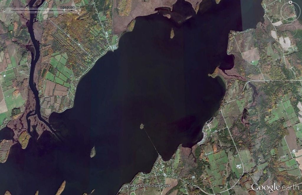
Pixl wrote:Another railroad under the water. If you look closely you can see the remains of a trestle below the surface crossing this lake. Someone may recognize it as this railroad has been discussed elsewhere on this board, but if necessary I'll throw out a few hints.
Empire! Our favorite beach up north. I had no idea about the submerged rails. Very cool.
It must have been for the lumber mill right?
Michael wrote:Empire! Our favorite beach up north. I had no idea about the submerged rails. Very cool.
It must have been for the lumber mill right?
You are correct. This was the Empire & South Eastern RR, Although built to serve the needs of the sawmill here, it also ran passengers and freight about 11 miles to the South where it met with the Manistee & North Eastern RR. I've walked most all of the road bed at one time or another, very interesting.
Great pictures of underwater bridges/tracks Pixl. I've been to the one west of Alpena but didn't see it. Next time I'll look much closer. I'll be sure to visit Empire next time I'm in the area. Might take my snorkeling equipment and do some underwater viewing
PatC created a monster, 'cause nobody wants to see Don Simon no more they want AARR I'm chopped liver, well if you want AARR this is what I'll give ya, bad humor mixed with irrelevant info that'll make you roll your eyes quicker than a ~Z~ banhammer...
The Empire and Southeastern??? I've never heard of it... learn something new everyday.
1223 OUT! President and Founder of the Buck Creek Central, the Rolling River Route! (2012-2017) President and Founder of the Lamberton Valley Railroad, The Tin Plate Road! Proudly railfanning with Asperger's since 1996.
AARR wrote: I'll be sure to visit Empire next time I'm in the area. Might take my snorkeling equipment and do some underwater viewing
That would be cool. Take some pictures and post them please! If you can find S. Reynolds St. in Empire, park on the North end and follow the grade West to the lake. No signs prohibiting last I was there. On the West side you will have to get friendly with the homeowner there, but nice people in the area.
I have one more underwater location that I have personally been to, but it is in Canada.
Last edited by James Sofonia on Fri May 29, 2015 11:11 am, edited 1 time in total.
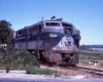
ConrailMan5 wrote:Don't be fooled on this one. That's a grade crossing light in the background, there are apartments behind the photographer
Wow, I see a lot of power, at least 4 locos. Would it be a long train downstate? When GLC is up here we only see one loco hauling one car most of the time in TC.
ConrailMan5 wrote:Don't be fooled on this one. That's a grade crossing light in the background, there are apartments behind the photographer
PatC created a monster, 'cause nobody wants to see Don Simon no more they want AARR I'm chopped liver, well if you want AARR this is what I'll give ya, bad humor mixed with irrelevant info that'll make you roll your eyes quicker than a ~Z~ banhammer...
59caddy wrote:Tricky, tricky that's Barton Dr in Ann Arbor, only this time with GLC locomotives leading because the AARR couldn't do the job alone.
Ding ding ding. Long grain train, AA locos stalled on the hill in subzero temperatures. 2 ex AA gp35's, a gp39, 1337, and another gp39 made up the consist.
"I tell you, we are here on Earth to fart around, and don't let anybody tell you different."
-Kurt Vonnegut
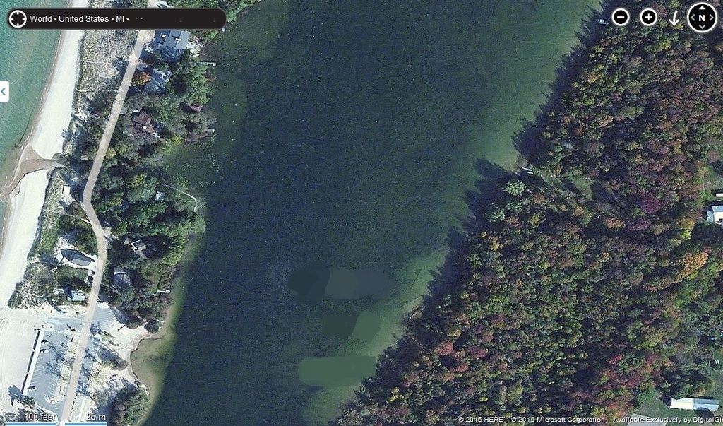
Pixl wrote:Here is the last of the underwater railroads that I've seen. I've been in a boat and floated right over this grade. It is within 70 miles of Toronto.
I don't even see it...
1223 OUT! President and Founder of the Buck Creek Central, the Rolling River Route! (2012-2017) President and Founder of the Lamberton Valley Railroad, The Tin Plate Road! Proudly railfanning with Asperger's since 1996.
Pixl wrote:Here is the last of the underwater railroads that I've seen. I've been in a boat and floated right over this grade. It is within 70 miles of Toronto.
Michael wrote:It looks like it goes through Rice Lake, connecting the towns of Harwood and Hiawatha and that Tic Island in the middle.
That be it!
They built a causeway out to Tic I.
From there it was the the worlds longest trestle in 1854 sitting on cribs about every 100 ft. The cribs are visible on Bing's Birdview.
Here is the North end
"The Cobourg and Peterborough Railway, (C&PRy) part of the Grand Trunk Railway (GT) crossed Rice Lake here in 1854. It started at Harwood on the south shore with a 1mi. earthen causeway. It continued on a 2 mi. rock filled wood cribs, every 100 ft. from Tic Island to here at the Hiawatha First Nations. It reached Peterborough in 1855. Moving ice destroyed it, and the dam at Hastings flooded it. It was the longest trestle bridge in the world at 2.6 miles."
Highland (CSX Saginaw Sub between Wixom and Holly)?
Michael wrote:There are not a lot of bridges left with C&O (both sides of the bridge in this case)
PatC created a monster, 'cause nobody wants to see Don Simon no more they want AARR I'm chopped liver, well if you want AARR this is what I'll give ya, bad humor mixed with irrelevant info that'll make you roll your eyes quicker than a ~Z~ banhammer...
AARR wrote:Highland (CSX Saginaw Sub between Wixom and Holly)?
Michael wrote:There are not a lot of bridges left with C&O (both sides of the bridge in this case)
Wrong Subdivision
Saginaw Sub? The bridge in Grand Blanc has 20 foot long PM signs on both sides. The paint is rusted off but if you look just right when the sun is out you can see the lettering. Unless they "beautified" it and ruined it like they wanted to. Apparently that bridge is an eyesore.
1223 OUT! President and Founder of the Buck Creek Central, the Rolling River Route! (2012-2017) President and Founder of the Lamberton Valley Railroad, The Tin Plate Road! Proudly railfanning with Asperger's since 1996.