The spur that serviced this grainery came about 1000 feet off the main crossing the road in front of this place.
I am actually making an assumption this place was served by rail based on topo maps and what we can see in the photo.
Now the tracks end about a half mile from this location.
Where Is It?
-
AARR
- Incognito and Irrelevant
- Posts: 38925
- Joined: Wed Dec 22, 2004 7:39 pm
- Location: Washington, MI
Re: Where Is It?
So it's not Vestaburg. How about Litchfield?
The spur that serviced this grainery came about 1000 feet off the main crossing the road in front of this place.
I am actually making an assumption this place was served by rail based on topo maps and what we can see in the photo.
Now the tracks end about a half mile from this location.
Michael wrote:

PatC created a monster, 'cause nobody wants to see Don Simon no more they want AARR I'm chopped liver, well if you want AARR this is what I'll give ya, bad humor mixed with irrelevant info that'll make you roll your eyes quicker than a ~Z~ banhammer...
-
railrod1949
- Railroadfan...fan
- Posts: 1317
- Joined: Mon Oct 26, 2015 8:19 am
- Location: Waterford, MI
Re: Where Is It?
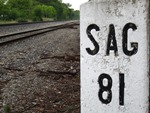
Litchfield Grain, Inc. on M-49, Litchfield, MI on the former LM&MS Railroad. In the Litchfield Community Schools district, Hillsdale County. It's have a Litchfield, MI 49252 address.Michael wrote:The spur that serviced this grainery came about 1000 feet off the main crossing the road in front of this place.
I am actually making an assumption this place was served by rail based on topo maps and what we can see in the photo.
Now the tracks end about a half mile from this location.
Just little southeast of the above shot is the Michigan South Central Power Plant on the north side Of Herring Road, just east of M-49. It's the remaining rail customer of INER RR. The main line trackage now ends just northwest of the power plant. The old NYC trackage between Albion and just northwest of St. joe Street, Litchfield via Homer was abandoned in 1943. The grainery spur had a connection with the main line trackage, just south of St. Joe Street, Litchfield.
Last edited by railrod1949 on Fri Mar 17, 2017 10:28 am, edited 1 time in total.
-
James Sofonia
- Grand Traverse Dinner Train 1996
- Posts: 1701
- Joined: Mon Mar 10, 2014 7:56 pm
- Location: Traverse City, Michigan
Re: Where Is It?
It would seem that the spur went off to the NW to connect to the main line. Looking at Google Earth and street view you can vaguely see the angled alignment of the drive into Marshall Street Motors, but beyond that there is no visible sign a spur was ever there. Can you put up the topo you were looking at?Michael wrote:The spur that serviced this grainery came about 1000 feet off the main crossing the road in front of this place.
I am actually making an assumption this place was served by rail based on topo maps and what we can see in the photo.
Now the tracks end about a half mile from this location.
-
~Z~

- Sofa King Admin
- Posts: 13154
- Joined: Tue Oct 12, 2004 2:14 pm
- Location: Grand Rapids, MI
- Contact:
Re: Where Is It?
Have an out of state one, but there should be enough markers here to tell. If you can guess the railline and not specific location, that'll work well enough.
http://i.imgur.com/w89rNC9.jpg

http://i.imgur.com/w89rNC9.jpg
Webmaster
Railroad photos on Railroadfan.com
Railroad photos on Railroadfan.com
Re: Where Is It?
Pixl wrote:It would seem that the spur went off to the NW to connect to the main line. Looking at Google Earth and street view you can vaguely see the angled alignment of the drive into Marshall Street Motors, but beyond that there is no visible sign a spur was ever there. Can you put up the topo you were looking at?
Good job AARR. This is the topo from 1948
The main is now a short rail trail in town and at one point (before 1948) the line continued north to Homer.
Just a little to the south is the coal power plant.

Re: Where Is It?
Arizona 98 crossing the Black Mesa and Lake Powell near the Navajo Generating station (northwest end of the railroad). The danger high voltage sign and desert scene were the giveaways.~Z~ wrote:Have an out of state one, but there should be enough markers here to tell. If you can guess the railline and not specific location, that'll work well enough.
http://i.imgur.com/w89rNC9.jpg
-
~Z~
- Sofa King Admin
- Posts: 13154
- Joined: Tue Oct 12, 2004 2:14 pm
- Location: Grand Rapids, MI
- Contact:
Re: Where Is It?
Righto PatAzo, figured the high voltage and desert parts would help 
Webmaster
Railroad photos on Railroadfan.com
Railroad photos on Railroadfan.com
-
railrod1949
- Railroadfan...fan
- Posts: 1317
- Joined: Mon Oct 26, 2015 8:19 am
- Location: Waterford, MI
Re: Where Is It?
Yes, agreed, that's Arizona 98 crossing the Black Mesa and Lake Powell RR southeast of Page, AZ, south of the Utah border, in the Page Unified Schools District, in Coconino County, AZ. Its looking southeast from the Navajo Generating Station (which is to the northwest of Arizona Highway 98). Its have a Page, AZ 86040 address.PatAzo wrote:Arizona 98 crossing the Black Mesa and Lake Powell near the Navajo Generating station (northwest end of the railroad). The danger high voltage sign and desert scene were the giveaways.~Z~ wrote:Have an out of state one, but there should be enough markers here to tell. If you can guess the railline and not specific location, that'll work well enough.
http://i.imgur.com/w89rNC9.jpg
Last edited by railrod1949 on Fri Mar 17, 2017 2:02 pm, edited 1 time in total.
Re: Where Is It?
Another one for you AARR

-
Jetlink

- Not a Railfan
- Posts: 3598
- Joined: Mon Jun 27, 2011 2:41 pm
- Location: 2.5 miles from CH 116.3
Re: Where Is It?
County, school district, and zip code are required for you to receive full credit.PatAzo wrote:Arizona 98 crossing the Black Mesa and Lake Powell near the Navajo Generating station (northwest end of the railroad). The danger high voltage sign and desert scene were the giveaways.~Z~ wrote:Have an out of state one, but there should be enough markers here to tell. If you can guess the railline and not specific location, that'll work well enough.
http://i.imgur.com/w89rNC9.jpg
interested in trains
Patiently waiting for LansingRailfan to antagonize me in his tagline
Patiently waiting for LansingRailfan to antagonize me in his tagline
-
AARR
- Incognito and Irrelevant
- Posts: 38925
- Joined: Wed Dec 22, 2004 7:39 pm
- Location: Washington, MI
Re: Where Is It?
Vermontville?
Michael wrote:Another one for you AARR
PatC created a monster, 'cause nobody wants to see Don Simon no more they want AARR I'm chopped liver, well if you want AARR this is what I'll give ya, bad humor mixed with irrelevant info that'll make you roll your eyes quicker than a ~Z~ banhammer...
Re: Where Is It?
Jetlink wrote:County, school district, and zip code are required for you to receive full credit.PatAzo wrote:Arizona 98 crossing the Black Mesa and Lake Powell near the Navajo Generating station (northwest end of the railroad). The danger high voltage sign and desert scene were the giveaways.~Z~ wrote:Have an out of state one, but there should be enough markers here to tell. If you can guess the railline and not specific location, that'll work well enough.
http://i.imgur.com/w89rNC9.jpg
railrod1949 wrote:, in the Page Unified Schools District, in Coconino County, AZ. Its looking southeast from the Navajo Generating Station (which is to the northwest of Arizona Highway 98). Its have a Page, AZ 86040 address.
-
Jetlink
- Not a Railfan
- Posts: 3598
- Joined: Mon Jun 27, 2011 2:41 pm
- Location: 2.5 miles from CH 116.3
Re: Where Is It?
I agree, I think it is Vermontville too. I've been by it many times.
interested in trains
Patiently waiting for LansingRailfan to antagonize me in his tagline
Patiently waiting for LansingRailfan to antagonize me in his tagline
-
railrod1949
- Railroadfan...fan
- Posts: 1317
- Joined: Mon Oct 26, 2015 8:19 am
- Location: Waterford, MI
Re: Where Is It?
Agree, also. it's Vermontville, looking west along the old NYC ROW (former MC, former NYC) in Vermontville, Maple Valley Schools district, Vermont Township, Eaton County.AARR wrote:Vermontville?Michael wrote:Another one for you AARR
It's have a Vermontville, MI 49096 address. The grainery in the photo above is the Citizens LLC.
-
Schteinkuh

- Railcam Terrorizer
- Posts: 687
- Joined: Sun Oct 16, 2011 4:06 pm
- Location: LansingRailFan’s Mom’s House
Re: Where Is It?
Let's take a quick moment to appreciate the MVPs of the internet for this kind of thing
https://heatst.com/tech/he-will-not-div ... -troll-it/
Regardless of political affiliation, you have to admit it's pretty outstanding.
https://heatst.com/tech/he-will-not-div ... -troll-it/
Regardless of political affiliation, you have to admit it's pretty outstanding.
According to all known laws of aviation, there is no way a bee should be able to fly. Its wings are too small to get its fat little body off the ground. The bee, of course, flies anyway because bees don't care what humans think is impossible.
-
Saturnalia
- Authority on Cat
- Posts: 15451
- Joined: Wed Sep 28, 2011 7:54 pm
- Location: Michigan City, IN
- Contact:
Re: Where Is It?
OMG that's great. You know you're into it when you use weather patterns, air traffic control, star gazing and honking horns to find a flagpole.Schteinkuh wrote:Let's take a quick moment to appreciate the MVPs of the internet for this kind of thing
https://heatst.com/tech/he-will-not-div ... -troll-it/
Regardless of political affiliation, you have to admit it's pretty outstanding.
Capture the flag indeed.
-
MQT1223

- O Scale Railfanner
- Posts: 4156
- Joined: Wed Sep 10, 2014 1:46 pm
- Location: Grandville, Michigan
- Contact:
Re: Where Is It?
Here's what I believe to be a hard one. You could cross this spot a thousand times and never know that a grade crossing even existed here.
The car in the driveway to the right is sitting on the ROW, and the tracks crossed diagonally from there to the bottom left of this picture. There is actually an old tie still in the ditch, and the ROW is so overgrown that it is impassible on the left side of this road.
A small hill on the right near the car marks what is left of the grade on the opposite side of the road. The rest as they say, is lost to history.
- Attachments
-
1223 OUT! President and Founder of the Buck Creek Central, the Rolling River Route! (2012-2017) President and Founder of the Lamberton Valley Railroad, The Tin Plate Road! Proudly railfanning with Asperger's since 1996.
-
~Z~
- Sofa King Admin
- Posts: 13154
- Joined: Tue Oct 12, 2004 2:14 pm
- Location: Grand Rapids, MI
- Contact:
Re: Where Is It?
What car in the driveway to the right? Did you upload the correct photo?MQT1223 wrote:The car in the driveway to the right
Webmaster
Railroad photos on Railroadfan.com
Railroad photos on Railroadfan.com
-
MQT1223
- O Scale Railfanner
- Posts: 4156
- Joined: Wed Sep 10, 2014 1:46 pm
- Location: Grandville, Michigan
- Contact:
Re: Where Is It?
I did. There is a bush blocking the car I did not mention. The garage, just to the left of it there is a car that is mostly obscured by the bush. Sorry about any discrepancies.~Z~ wrote:What car in the driveway to the right? Did you upload the correct photo?MQT1223 wrote:The car in the driveway to the right
1223 OUT! President and Founder of the Buck Creek Central, the Rolling River Route! (2012-2017) President and Founder of the Lamberton Valley Railroad, The Tin Plate Road! Proudly railfanning with Asperger's since 1996.