Where Is It?
-
~Z~

- Sofa King Admin
- Posts: 13192
- Joined: Tue Oct 12, 2004 2:14 pm
- Location: Grand Rapids, MI
- Contact:
Re: Where Is It?
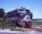
You guys are hot.. not the right island yet though 
Webmaster
Railroad photos on Railroadfan.com
Railroad photos on Railroadfan.com
Re: Where Is It?
I want to know how you got to that image~Z~ wrote:You guys are hot.. not the right island yet though
https://goo.gl/maps/UVBRJAbD2hJ2
-
~Z~
- Sofa King Admin
- Posts: 13192
- Joined: Tue Oct 12, 2004 2:14 pm
- Location: Grand Rapids, MI
- Contact:
Re: Where Is It?
You got the right spot, that's St Kitts in the Caribbean. How I got to that image... so I was browsing some spots when researching summertime vacation. Was looking at a couple airports to see what is potentially serviced by just a single stop between my home city and where to vacation so we aren't switching planes a number of times. Was showing my kiddos on a map where the service desk agent I was talking to was from (Jamaica) and thought to look at an island I've visited before, St Kitts. Found you could potentially fly GR to miami on a new service that's being offered this year, then miami to St Kitts. Pulled up street view to follow the railroad around the island, which I rode back in 2009. Saw this particular street view, and wanted to include it as a "where is it?" postDaveO wrote:I want to know how you got to that image~Z~ wrote:You guys are hot.. not the right island yet though
https://goo.gl/maps/UVBRJAbD2hJ2
Here's a gallery with some photos I took from that trip:
http://railroadfan.com/gallery/thumbnails-1613.html

Webmaster
Railroad photos on Railroadfan.com
Railroad photos on Railroadfan.com
Re: Where Is It?
It definitely had the sugarcane railroad look.~Z~ wrote:You got the right spot, that's St Kitts in the Caribbean. How I got to that image... so I was browsing some spots when researching summertime vacation. Was looking at a couple airports to see what is potentially serviced by just a single stop between my home city and where to vacation so we aren't switching planes a number of times. Was showing my kiddos on a map where the service desk agent I was talking to was from (Jamaica) and thought to look at an island I've visited before, St Kitts. Found you could potentially fly GR to miami on a new service that's being offered this year, then miami to St Kitts. Pulled up street view to follow the railroad around the island, which I rode back in 2009. Saw this particular street view, and wanted to include it as a "where is it?" postDaveO wrote:I want to know how you got to that image~Z~ wrote:You guys are hot.. not the right island yet though
https://goo.gl/maps/UVBRJAbD2hJ2
Here's a gallery with some photos I took from that trip:
http://railroadfan.com/gallery/thumbnails-1613.html
Knew it wasn't Cuba, too prosperous looking. Yes, really.
Didn't look like Puerto Rico which you dismissed.
Also dismissed the DR.
That left Jamaica where from what I gather online, the bauxite mines ship by rail to the port. But not on that kind of track work.
So it had to be St. Kitts. I started from the station and clicked on the streetview images that matched the road, track, housing scenario.
And voila.
-
SteveHiuzenga

- Railroadfan...fan
- Posts: 822
- Joined: Wed Aug 01, 2007 7:10 pm
- Location: Zeeland
Re: Where Is It?
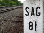
Here is an easy one......
-
~Z~
- Sofa King Admin
- Posts: 13192
- Joined: Tue Oct 12, 2004 2:14 pm
- Location: Grand Rapids, MI
- Contact:
Re: Where Is It?
Muskegon Corner of Edgewater St and Thompson Ave down near Pere Marquette Beach.
Webmaster
Railroad photos on Railroadfan.com
Railroad photos on Railroadfan.com
-
SteveHiuzenga
- Railroadfan...fan
- Posts: 822
- Joined: Wed Aug 01, 2007 7:10 pm
- Location: Zeeland
Re: Where Is It?
that road is in really bad shape, i am surprised it has not be resurfaced, but when it is, I am sure these leftovers will be gone....
-
railrod1949
- Railroadfan...fan
- Posts: 1317
- Joined: Mon Oct 26, 2015 8:19 am
- Location: Waterford, MI
Re: Where Is It?
~Z~ wrote:Muskegon
Yup, that's looking southwest along Thompson Avenue towards the east shore of Lake Michigan from Edgewater Street in Muskegon, Muskegon County. Just a couple of blocks west of the west shore of Muskegon Lake.

Re: Where Is It?
Looking at the satellite image, it appears that some street running once occurred on Thompson St. Where did those tracks go? How long ago were they removed?
At the west end of the old Sappi property, the tracks used to cross Lakeshore Dr. However, following where those tracks went doesn't appear to lead to Thompson St. Was there another set of tracks that hooked to the northwest and through the property where Balcom's Cove Condos currently stand?
At the west end of the old Sappi property, the tracks used to cross Lakeshore Dr. However, following where those tracks went doesn't appear to lead to Thompson St. Was there another set of tracks that hooked to the northwest and through the property where Balcom's Cove Condos currently stand?
https://www.flickr.com/photos/jimthias/
GRHC - you know every night I can imagine he is in front of his computer screen sitting in his underwear swearing profusely and drinking Blatz beer combing the RailRoadFan website for grammatical errors.
GRHC - you know every night I can imagine he is in front of his computer screen sitting in his underwear swearing profusely and drinking Blatz beer combing the RailRoadFan website for grammatical errors.
-
AARR
- Incognito and Irrelevant
- Posts: 39076
- Joined: Wed Dec 22, 2004 7:39 pm
- Location: Washington, MI
Re: Where Is It?
Possibly GTW ferry dock tracks were in that area?
J T wrote:Looking at the satellite image, it appears that some street running once occurred on Thompson St. Where did those tracks go? How long ago were they removed?
At the west end of the old Sappi property, the tracks used to cross Lakeshore Dr. However, following where those tracks went doesn't appear to lead to Thompson St. Was there another set of tracks that hooked to the northwest and through the property where Balcom's Cove Condos currently stand?
PatC created a monster, 'cause nobody wants to see Don Simon no more they want AARR I'm chopped liver, well if you want AARR this is what I'll give ya, bad humor mixed with irrelevant info that'll make you roll your eyes quicker than a ~Z~ banhammer...
Re: Where Is It?
The tracks crossing the street served the building just over the road (what is now part of Torresen Marine, used to build refrigerators I believe). The street tracks were part of the muskegon street railway line. I know they went through Blufton, and I believe all the way to Pere Marquette beach. Somewhere I have an article about that line.
GTW docks were about 1/2 - 3/4 mile east of the picture. The location of the diamond is still visible where the GTW crossed tge PM.
GTW docks were about 1/2 - 3/4 mile east of the picture. The location of the diamond is still visible where the GTW crossed tge PM.
Re: Where Is It?
2 railroads intersected here

-
railrod1949
- Railroadfan...fan
- Posts: 1317
- Joined: Mon Oct 26, 2015 8:19 am
- Location: Waterford, MI
Re: Where Is It?
Michael wrote:2 railroads intersected here
Not in Michigan!~ Oak Harbor, OH. Former W&LE RR over the NS RR.
Re: Where Is It?
I'm going with the U.P. between Ironwood and Bessemer. Looks like Soo Line and the DSS&A.Michael wrote:2 railroads intersected here
-
railrod1949
- Railroadfan...fan
- Posts: 1317
- Joined: Mon Oct 26, 2015 8:19 am
- Location: Waterford, MI
Re: Where Is It?
PatAzo wrote:I'm going with the U.P. between Ironwood and Bessemer. Looks like Soo Line and the DSS&A.Michael wrote:2 railroads intersected here
Yup, the old DSS&A over the C&NW between Bessemer and ironwood in the da UP. In Bessemer Township, Gogebic County. Passenger train service on the ex C&NW between Ironwood and Watersmeet was discontinued many years ago. Passenger train service on the exDSS&A was discontinued many years as well.
-
SteveHiuzenga
- Railroadfan...fan
- Posts: 822
- Joined: Wed Aug 01, 2007 7:10 pm
- Location: Zeeland
Re: Where Is It?
-
SteveHiuzenga
- Railroadfan...fan
- Posts: 822
- Joined: Wed Aug 01, 2007 7:10 pm
- Location: Zeeland
Re: Where Is It?
The ovals, as they are referred to my locals, is the current road that goes around Pere Marquette Park along Lake Michigan...that road is on top of the right of way that was once there....the Muskegon Streetcar Company gave the land to the city when they went out of business and the city just put a road where the tracks were. The tracks did indeed go along Lakeshore Drive, just along the north side of it. For a while every driveway had rail going across them but over time the have all been removed or simply paved over.
Re: Where Is It?
Good job on that last one PatAzo. Here's another.

Re: Where Is It?
It's a Pleasure when the road name is translated into EnglishMichael wrote:Good job on that last one PatAzo. Here's another.
Re: Where Is It?
15114 Laplaisance RdDaveO wrote:It's a Pleasure when the road name is translated into EnglishMichael wrote:Good job on that last one PatAzo. Here's another.
Monroe, Michigan..... At least that's my best guess